While the last few days have been cold and snowy (with more on the way!), early February brought widespread heat across the state, including the Front Range, West Slope, and mountains. Warm spells are not uncommon during the winter months, but this heat was particularly intense and long-lasting for many locations. So, how warm did it get, and how unusual was it? Read on for some eye-catching statistics, and we’ll also share a peek at what’s in store for the rest of February.
Records shattered
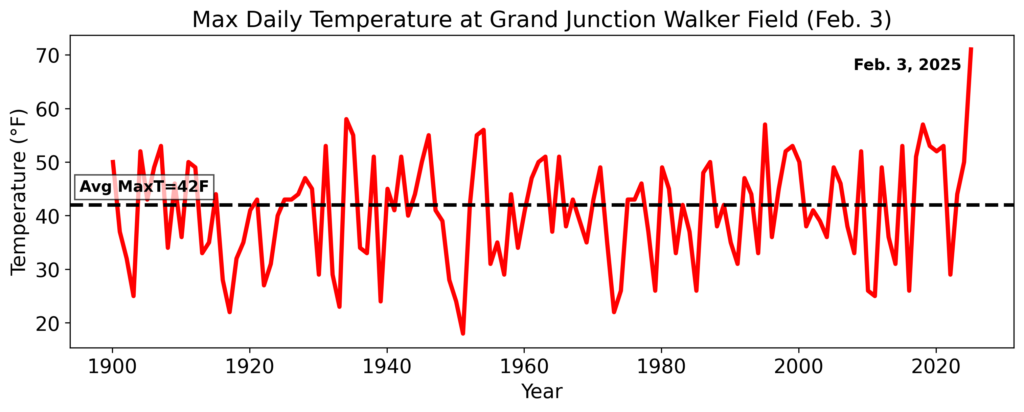
The intensity of the heat in early February was significant, with at least 50 daily records broken by 5°F or more. The Western Slope was the epicenter of this substantial heat, and so we highlight Grand Junction Walker Field here as an example. Some striking statistics from that site:
- A new daily record high temperature was recorded for 6 straight days (February 2-7).
- 5 of the 6 new daily maximum records exceeded the previous record by 6°F or more.
- On February 3, the high temperature of 71°F beat the previous daily maximum by 13°F (58°F, set in 1934).
- The high temperature of 71°F on February 3 also marks Grand Junction’s warmest winter (December/January/February) temperature on record. This record was previously set in 1904!
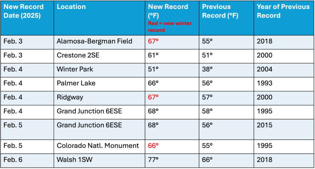
Other locations broke their previous daily maximum temperature records by substantial margins as well. Like Grand Junction, some of these values were so extreme that they additionally qualified as all-time records not just for the month of February, but for all of climatological winter (December-January-February). Here are other stations that set new daily records by 10°F or more (note that only stations with at least 40 years of data are considered):
Records as old as a century were broken
As the planet continues to warm, many of our earliest maximum temperature station records (that is, late 19th/early 20th century) have been broken relatively recently (in the 21st century). However, the early February heat was anomalous enough to break a number of long-standing temperature records, including some dating back to the Roaring 20s and Dust Bowl eras. For example, Lamar saw a high temperature of 74°F on February 6th, breaking the previous daily record of 70°F that was set back in 1925 (100 years ago)! Here are some other notable records from the 1920s and 30s that were broken this month:
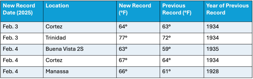
While this list highlights some of the oldest records that fell, there were a number of additional broken records that were previously set in 1950s and 60s—still very impressive!
How did this event stack up against previous winter heatwaves?
The early February heat was not only intense, but it was also long-lasting. Many locations (such as Grand Junction and Winter Park) set or tied daily record high temperatures across several days.
We can quantify how intense this stretch of heat was by examining the temperatures in the context of past winter (December/January/February) heatwaves. Heatwaves are identified by examining average daily temperatures across 4-day periods from 1951 to present (using data from NOAA’s ncClimGrid dataset). The 4-day periods with the greatest average temperature across those four days are considered the most intense heatwaves in the data record (note that overlapping 4-day periods are excluded, so that there are not duplicates of the same heatwave in the dataset). To measure the intensity of this heatwave on a more local level, we can compute separate statistics for each of the 11 alternate climate divisions (defined in the Climate Change in Colorado report). These climate divisions are classified by long-term variability in temperature and precipitation observations. Analyzing the data in this way allows us to better contextualize the significance of this heat across unique regions that are characterized by some climatic similarities.
The early February heat was the most intense since at least 1950 for the Northwest and Mesas & Valleys regions and the second-most intense for the San Luis Valley & Sangre de Cristos division. The heatwave also ranked in the top-10 for several other climate divisions. Yet, examining these data for the state as a whole, the February heatwave only ranked #23 statewide. Why?
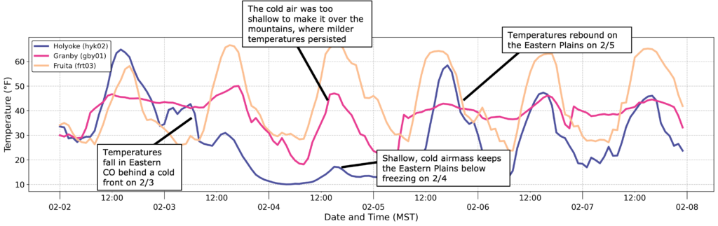
This discrepancy can be attributed to weather patterns over the Eastern Plains, where there was a taste of spring in early February, but it was not nearly as persistent as the rest of the state. Although temperatures warmed to record or near-record highs across most of Colorado on February 3, they quickly took a nosedive in eastern Colorado as a cold front moved in from the northeast. This cold airmass was very shallow and therefore unable to overcome the steep terrain. As a result, only the Eastern Plains and I-25 Corridor experienced the temperature drop, while elevated terrain and the West Slope stayed warm. To illustrate this contrast using the example below, Granby (which sits around 8,000 ft) recorded a maximum temperature roughly 30°F warmer than Holyoke (located near the Colorado/Nebraska border) on February 4th! So, while the mountains and western Colorado experienced truly remarkable heat over the course of nearly a week, the cold air over eastern Colorado mitigated the potential for a substantial state-wide heatwave.
What can we expect for the rest of February?
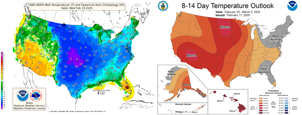
After a solid weekend of mountain snow, additional precipitation is expected to continue early this week. However, extended forecasts beyond this system look grim for snow lovers (more on that in an upcoming blog post this week). Temperature-wise, below-average temperatures are on deck for eastern Colorado this week, while folks west of the Continental Divide can expect near-normal to slightly above-average temperatures. After this week’s upcoming cold snap, more warm weather is likely on the way for the last week of February. You might be able to give your skis a break for the tail end of February, but we still have plenty of winter left, so let’s keep our fingers crossed for a snowy March!