|
|
Drought Early Warning System June 30, 2020 |
|
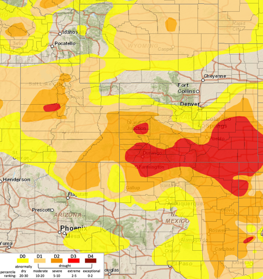 Current U.S. Drought Monitor Depiction |
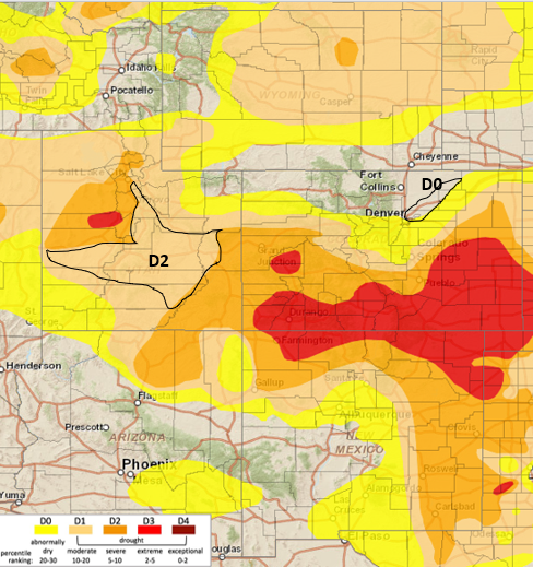 Recommended Changes |
Summary: June 30, 2020
Last week the Intermountain West region saw dry conditions west of the Continental Divide and spotty precipitation east of the Divide. The Upper Colorado River Basin and Arizona saw little to no precipitation. Northwest Utah and northwest Wyoming did see some nice precipitation amounts. Eastern Colorado, Wyoming and New Mexico saw spotty precipitation with the higher amounts up to 2" and the lower amounts less than 0.25".
Temperatures over the region were still above normal, in the 2 to 4 degrees above normal range. This was a slight break compared to the rest of the month for eastern Colorado, which has seen temperatures in the 4-8 degree above normal range.
The hot conditions this month in eastern Colorado have had a very large impact on the evaporative demand. Reference evapotranspiration rates have increased significantly in June to the point where what little precipitation has fallen is evaporated back to the atmosphere before it can do any good to plants. There are reports that even the weeds in southeast Colorado did not have much of a green-up.
Streamflow in the UCRB has decreased significantly and most streamgages in the basin are reporting below to much below normal flows. The key sites on the Colorado, Green and San Juan rivers are now below normal flows. In eastern Colorado, streamflows are still in the normal range, for the most part, however, after an early melt out, flows are expected to come down sooner than normal.
The precipitation outlook for the next 7 days is showing some precipitation through the middle of Colorado extending into northern New Mexico and the San Juan Mountains. The rest of the IMW is looking dry. The 8-14 day outlook does not look good, with elevated chances of above normal temperature and below normal precipitation.
Recommendations:
UCRB: Status quo for most of the UCRB, see Utah recommendations for the western portion of the Basin. Conditions seem to match up with the USDM depiction.
Eastern Colorado: An increase of D0 into Weld County covering all of Morgan County is recommended. This area has been drying out and missed out on the precipitation that fell last week. This D0 increase will extend from the D0 to the southeast.
Utah: It is being recommended the D2 drought areas in Utah be connected through Emery, Sanpete, Sevier, Millard, Wayne, and part of Garfield counties. This area according to data and on the ground reports is just as bad as other D2 areas in Utah.
Visit the U.S. Drought Monitor