|
Drought Early Warning System June 30, 2020 |

|

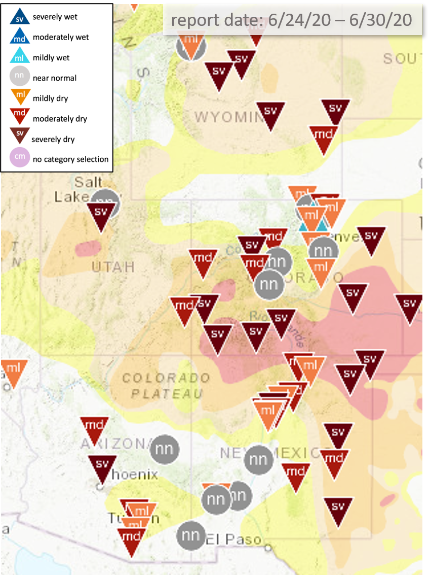
Condition Monitoring Reports are submitted to CoCoRaHS by volunteers who are observing conditions in the region near where they take their observations. View Current Condition Monitoring Map.
Utah:
Millard County is very dry with numerous fires. Range conditions in central Utah are very poor.
Colorado:
Southeast CO: It looks like the middle of winter, there is no green and everything, even native grasses and weeds are not growing. Any moisture that falls is immediately zapped by high temperatures and winds. Due to a short spring, grasshoppers were about a month late. Rocky Ford has implemented municipal water restrictions.
Southcentral CO: Dry and windy in most over most of the area. There was some beneficial precipitation between Canon City and Pueblo that allowed native grasses to green up, but that's about it. Irrigation companies are getting nervous about having enough water through the end of the season.
Western CO: Although it's been dry, they feel it hasn't been as bad as eastern CO lately. Has not been as hot this last month with multiple little cold fronts coming through to keep temperatures "cooler". Range conditions are still not in great shape and it's been tough to get livestock processed. It's too late for a good monsoon to do any good at this point in the season since most of the grasses have already stopped growing. The Grand Mesa is significantly dry but the mountains to the east look better.
Southwest CO: Very dry. Have been some storms above Pagosa Springs, but precipitation hasn't made its way down. Dew points have been so low in Pagosa that 27F temperatures a few weeks ago didn't even put frost on the ground. Cortez does not look good, just very dry.
SLV: Very dry. About an inch of precipitation since October 1 in the CoCoRaHS gauge. Folks are moving cows to the mountains this week. The lower elevation range is at about 30% of normal usage. And some mountain pastures around 9000-9500ft may not be grazable this year. Ditches that pull from the Rio Grande that normally shut off much later in the summer and into fall, were shut off two weeks ago. There probably won't be much recharge to the aquifer and groundwater sprinklers will probably be shut off early.
Northeast CO: May was okay on the plains, then June was dry and hot. It looked like it was going to be a good harvest until June. Wheat harvest will be at least 2 weeks earlier than expected. It was looking good and healthy until recently. Grasses greened up, but didn't grow. Luckily the South Platte basin has good reservoir storage so irrigators should be in better shape. There may be some ground water pumping issues though.