


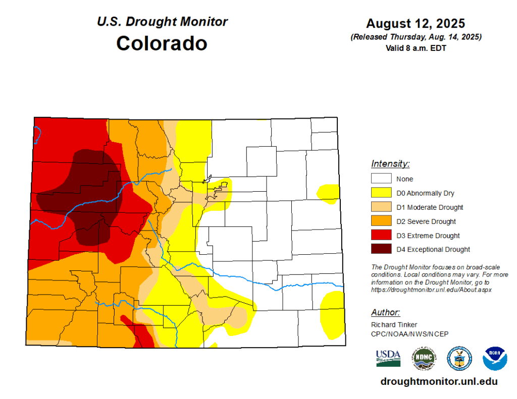
The latest US Drought Monitor (released August 14) highlights big changes to the current drought situation in western Colorado, including the introduction of “exceptional” or “D4” conditions to some locations. Exceptional drought represents the most severe category of drought and is frequently tied to widespread hydrologic and agricultural impacts.
Historical context and current impacts
Exceptional drought hasn’t been seen in Colorado since May 2023, when a very small fraction of the southeast corner of the state (Baca County) was classified under such conditions. And the last time that exceptional drought conditions were realized in the western half of the state was nearly four years ago in October 2021, when parts of Moffat County were included in the D4 category. The current exceptional drought area covers a larger fraction of the state than either of those two recent examples (roughly 7% of it) and includes portions of Moffat, Routt, Rio Blanco, Garfield, Eagle, Pitkin, Gunnison, Delta, and Mesa counties.
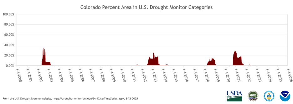
Colorado’s “high and dry” climate makes it no stranger to drought, and some part of the state will be experiencing some degree of drought at any nearly any given time. However, long-lived exceptional drought tends to be rarer. Since the inception of the US Drought Monitor, there have been four widespread and persistent periods of exceptional drought, with the most recent being 2020-2021.
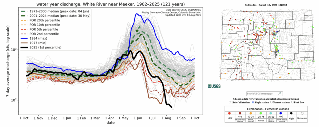
Current impacts to water, soils, and vegetation in the most drought-afflicted areas help capture the current severity of the situation. For example, streamflow along the White River at Meeker is in the 1st percentile among its 121-year record, and current flow is very close to the station’s all-time record low. Many other streamgauge sites, including those along the Yampa, Colorado, Animas, and Dolores rivers, show streamflow below the 10th percentile, indicating well below-normal flow conditions.
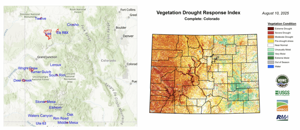
The multiple wildfires currently burning across western Colorado are evidence that there is stress on vegetation and soils in the drought-afflicted areas. This includes the Lee Fire (near Meeker, CO), which at over 127,000 acres is now firmly Colorado’s fifth-largest wildfire on record. Satellite-based drought products show severe vegetation stress and soil moisture percentiles below the 5th percentile, further confirming that surface conditions are extremely dry in western Colorado.
How did we get here? A look back at Water Year 2025
With only about a month and a half left in Water Year 2025, it is worth looking back at how the drought landscape has changed in Colorado since last October. Water years run from October 1 to September 30 and are designed to capture the movement of water from the time that streamflows are generally at their minimum (in the fall), through the build up of the water supply as snowpack during the winter, to the annual runoff in the spring and summer. Keeping track of drought and precipitation over the course of a water year is helpful for tracking and managing water resources.
At the start of the Water Year 2025, nearly everywhere west of the Continental Divide was drought-free, while the Front Range, Urban Corridor, and parts of the Eastern Plains were experiencing moderate to severe drought conditions. That pattern has switched in many ways, with most areas east of the Divide now currently drought-free, while nearly everywhere west of the Divide is being impacted by at least D1 drought conditions. The class change map comparing the drought monitor at the start of Water Year 2025 to the current drought monitor highlights this shift well:
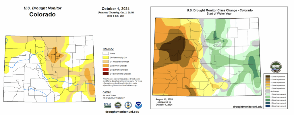
The current drought in western Colorado did not immediately unfold at the onset of the new water year. In early winter, drought was largely avoided in this area in part thanks to a major snowstorm in early November (refresh your memory with our blog post here). That event brought drought relief to much of the Eastern Plains and gave an early boost to the winter snowpack for most of the rest of the state.
However, the snow largely ceased across southern Colorado in December and January, and substantial high country snowpack deficits became apparent by the end of February, with the snowpack in several basins standing at only ~2/3rds of average. At the beginning of March, most of southwestern Colorado and the lower elevations of the West were experiencing D1-D2 drought conditions according to the US Drought Monitor.
While the state’s northern river basins were spared from significant snowpack deficits for most of the winter, March and April ended up being drier than normal. For this part of Colorado, the spring months are typically the wettest on average, and they are crucial months for amassing snowpack to accommodate warm season water needs (in the form of runoff). While deficits remained in better shape compared to southern Colorado’s basins, snowpack peaked earlier than normal across much of the state. This below-average winter snowpack has undoubtedly played an important role in the current drought situation across the western half of the state.
This brings us to mid-May—the last time we wrote a blog post about drought. By that time, most areas west of the Continental Divide were experiencing some level of drought, including D3 or “extreme” drought conditions over parts of the West Slope and San Juans. Aside from a decent precipitation event in early June, conditions in western Colorado have been abnormally hot and dry. Northwest Colorado has seen some of the quickest drought development in the state, with some locations going from D0-D1 conditions in Mid-May to D3-D4 conditions just three months later. June-July 2025 was among the top-10 hottest and driest on record for most of that area.
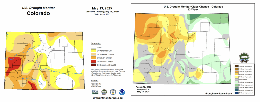
While areas east of the Divide saw some drought development in the spring as well, much of that was alleviated thanks to widespread and persistent thunderstorm activity throughout the summer. This regular rainfall has also continued to help ward off major drought development (though some locations that have missed out on recent precipitation, such as the Denver Metro, have begun to slip back into drought conditions). Locations west of the Divide have not been as fortunate. These areas typically benefit from the North American Monsoon (NAM), which (when active) provides increased moisture and precipitation throughout July and August. The lack of relief from the NAM combined with the below-average snowpack from last winter have brought us to the current drought situation.
What can we expect in the coming weeks/months?
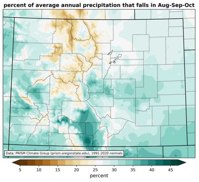
First, let’s briefly talk precipitation climatology (stay tuned for more on this in an upcoming blog post). For much of the West Slope, August-October tends to be the time of year that this area receives its greatest amounts of precipitation. Seeing that we’re only about halfway through August, there is plenty of time remaining in this wetter time of year. However, this seasonality does not guarantee “drought-busting” precipitation, nor should we expect our weather patterns to perfectly follow climatology.
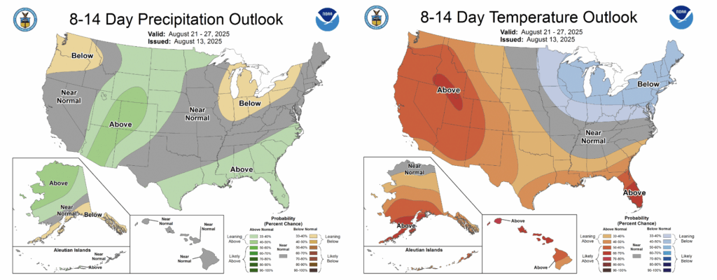
Still, there is a little hope in the medium-range outlook for precipitation in the western half of the state. The 8-14 day precipitation outlook from the NOAA Climate Prediction Center suggests elevated chances for above-average precipitation towards the end of the month, with the greatest likelihood spanning the western and central parts of the state. At the same time, above-average temperatures are expected to persist over this time frame, which could work against precipitation driven drought relief (warmer temperatures are connected to increased evaporative demand, or potential water loss from the Earth’s surface).
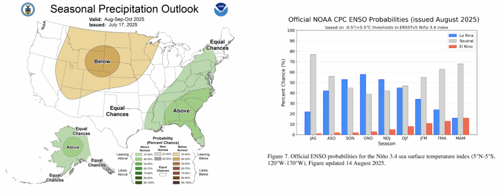
Looking even further ahead, the Climate Prediction Center 3-month outlook (August-October) that was released in mid-July does not inspire much optimism for drought relief as we head into fall. Their predictions call for elevated chances of below-normal precipitation across most of Colorado. Additionally, it is becoming increasingly likely that La Niña conditions will develop in late fall to early winter. While there is some evidence that La Niña favors wetter conditions over parts of north and central Colorado during the winter months, it favors overall drier conditions statewide, especially during the fall (though the correlations between ENSO phase and precipitation are relatively weak compared to other locations).
To summarize: poor snowpack during the winter teed up western Colorado for drought heading into summer, and the dry, hot conditions over the past few months have exacerbated conditions. These factors have lead to the widespread extreme to exceptional drought conditions that are currently depicted in the US Drought Monitor. There are a couple reasons to remain optimistic about precipitation in following weeks and months, but many uncertainties remain, and *a lot* of precipitation will be needed to alleviate drought conditions in western Colorado.