


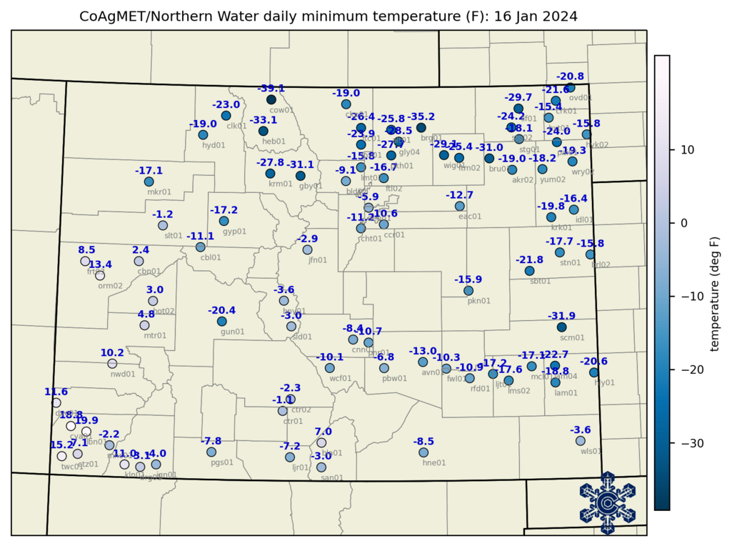
In mid-January 2024, it got brutally cold across Colorado. The lowest temperatures were on the morning of January 16th, and the map of low temperatures from CoAgMET shows a lot of negative numbers! The lowest on this map is -39.1°F at Cowdrey in North Park (near the Wyoming border), though that’s maybe not *so* impressive because it’s more common for extreme cold to happen in North Park. Some of the really eye-catching numbers are at Briggsdale (-35.2°F) and Kersey (-31.6°F) in Weld County, and at the Sand Creek Massacre Historic Site (-31.9°F) in Kiowa County. These were the lowest temperatures ever recorded at these stations, which were established in 2002, 1992 and 2008, respectively. It got down to -30°F at the Limon airport (not shown on this map), which is the lowest temperature on record for that station, with data back to 1948. These low temperatures happened at the tail end of four days of extreme cold across eastern Colorado.
So where did the mid-January 2024 cold wave rank with respect to other cold-air outbreaks in eastern Colorado? To look at this question, we’ll use NOAA’s nClimGrid-daily dataset, averaged over the alternate climate divisions for Colorado that we developed recently. The recent cold wave really lasted four days—from January 13-16th in northern Colorado; shifted a day later in the south—which conveniently aligns with the analysis of 4-day cold waves in the recently published Climate Change in Colorado report. This takes into account both the daytime high and nighttime low temperatures during the cold waves.
Below are the rankings of 4-day cold waves in the southeast, northeast, and northern Front Range regions, since the beginning of the dataset in 1951. The mid-January 2024 cold wave ranked as the 8th-coldest 4-day period since 1951 in both the southeast and northeast regions. For the northern Front Range, it ranked as the 15th coldest.

You might notice that the top 3 cold waves are the same on all three lists, though in different orders for the different regions. We can think of these as the “big 3” cold outbreaks for eastern Colorado in recent decades, in December 1983, February 1989, and February 1990. These were all periods with multiple days of high temperatures below zero and low temperatures in the double digits below zero. The highs during the January 2024 cold outbreak generally managed to get above zero in most of eastern Colorado, so the overall cold wave wasn’t as extreme as these.
Another interesting finding is that two of the eight coldest 4-day periods since 1951 in both northeast and southeast Colorado have occurred in the last few winters: the February 2021 cold outbreak and the recent mid-January event. The rapid drop in temperature from December 2022 (mentioned here) didn’t make these lists because while it did get very cold, the cold air mass was only around for about two days.
One limitation of the nClimGrid-daily dataset is that it doesn’t go back before 1951. The lowest temperature that we can find anywhere in the records for low-elevation stations in eastern Colorado was -45°F at Greeley in on February 12, 1899. This happened during the historic cold outbreak generally regarded as the most extreme in the continental US since records have been taken. It’s possible that if the density of stations we have now existed in 1899, some even lower temperatures would’ve been observed in that Arctic blast. And as a refresher, the all-time record low for all of Colorado is -61°F at Maybell in northwest Colorado on February 1, 1985.
So are there broader trends in extreme cold across Colorado? This was addressed in detail in chapter 4 of Climate Change in Colorado. Even though the state (and world) are consistently warming, and there are some modest trends toward fewer cold waves since 1951 in most of Colorado, these trends are relatively small and not statistically significant. This turns out to be consistent with what climate models project for the future in Colorado: continued overall warming, a very large increase in summer heat waves, but only modest declines in extreme cold. This was a particularly interesting finding from the report, and if interested in the topic, you can read more here. (Expect more posts about this report in the coming weeks!)
The January 2024 Arctic blast: very cold, but not historically so
The takeaway messages from the mid-January 2024 Arctic blast are that it ranked in the top 10 to 20 cold outbreaks for eastern Colorado, but didn’t measure up to those that happened in 1983, 1989, and 1990. And that while Colorado continues to warm on average, we’re still likely to experience periods of extreme cold from time to time.